ST. PETERSBURG, Fl — Hurricane Dorian is moving at a crawl to the west-northwest at 1 mph as it continues to devastate the Bahamas.
The Category 4 hurricane was about 25 miles northeast of Freeport and roughly 105 miles east of West Palm Beach, Florida, according to the National Hurricane Center’s latest advisory.
The storm is producing maximum sustained winds up to 145 mph, with Juno Beach, Florida, reporting a sustained tropical-storm-force gust as a result of Dorian being nearby.
Grand Bahama Island continues to experience catastrophic winds and storm surge. Dorian earlier made landfall on the eastern end of Grand Bahama Island as a powerful Category 5 hurricane. It first made landfall in Elbow Cay, Bahamas, around 12:45 p.m. Sunday with maximum sustained winds of 185 mph.
Hurricane Dorian’s falling wind speeds made it a Category 4 storm Monday morning, and they’ve continued to fall since.
However, Dorian remains an extremely destructive storm.
The most reliable weather computer models have been consistent in keeping the powerful storm just off the Florida coast and away from landfall. These models, however, are not forecasts — and they tend to change with every update.
In fact, some models include parts of Florida’s east coast for significant impacts or a potential landfall.
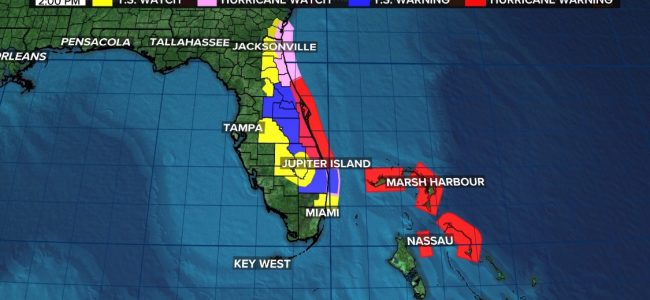
The following watches and warnings are in effect:
Hurricane warning: Grand Bahama and the Abacos Islands, Jupiter Inlet to the Flagler/Volusia County line
Hurricane watch: North of Deerfield Beach to Jupiter Inlet, Flagler/Volusia County line to the Altamaha Sound Georgia
Tropical storm warning: North of Deerfield Beach to Jupiter Inlet
Tropical storm watch: North of Golden Beach to Deerfield Beach, Lake Okeechobee
Storm surge warning: Lantana to the Flagler/Volusia County line
Storm surge watch: North of Deerfield Beach to south of Lantana, Flagler/Volusia county Line to the Savannah River